|
|
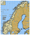
 The land
|
Copyright © 1994-2002 Encyclopedia Britannica, Inc.
Norway occupies part of northern Europe's Fennoscandian Shield. The extremely hard bedrock, which consists mostly of granite and other heat- and pressure-formed materials, ranges from one to two billion years in age.
Relief
 Glaciation and other forces wore down the surface and created thick sandstone, conglomerate, and limestone deposits known as sparagmite; numerous extensive areas called peneplains, whose relief has been largely eroded away, also were formed. Remains of the latter include the Hardanger Plateau—3,000 feet (900 metres) above sea level—Europe's largest mountain plateau, covering about 4,600 square miles (11,900 square km) in southern Norway; and the Finnmark Plateau (1,000 feet [300 metres] above sea level), occupying most of the northernmost and largest county of Norway. Glaciation and other forces wore down the surface and created thick sandstone, conglomerate, and limestone deposits known as sparagmite; numerous extensive areas called peneplains, whose relief has been largely eroded away, also were formed. Remains of the latter include the Hardanger Plateau—3,000 feet (900 metres) above sea level—Europe's largest mountain plateau, covering about 4,600 square miles (11,900 square km) in southern Norway; and the Finnmark Plateau (1,000 feet [300 metres] above sea level), occupying most of the northernmost and largest county of Norway.
From the Cambrian through the Silurian geologic periods (i.e., from about 540 to 408 million years ago), most of the area was below sea level and acquired a layer of limestone, shale, slate, and conglomerate from 330 to 525 feet (100 to 160 metres) thick. Folding processes in the Earth then gave rise to a mountain system that is a continuation of the Caledonian System of the British Isles. Norway has an average elevation of 1,600 feet (500 metres), compared with 1,000 feet (300 metres) for Europe as a whole.
Rivers running westward acquired tremendous erosive power. Following fracture lines marking weaknesses in the Earth's crust, they dug out gorges and canyons that knifed deep into the jagged coast. To the east the land sloped more gently, and broader valleys were formed. During repeated periods of glaciation in the Great Ice Age of the Quaternary Period (about two million years ago) the scouring action of glaciers tonguing down the V-shaped valleys that were then part of the landscape created the magnificent U-shaped drowned fjords that now grace the western coast of Norway. Enormous masses of earth, gravel, and stone were also carried by glacial action as far south as present-day Denmark and northern Germany. The bedrock, exposed in about 40 percent of the area, was scoured and polished by the movements of these materials.
|
 |
|
Anons |

|
| Links |


|
|